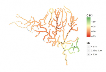
Bioassessment scores to be extrapolated for 4 modified streams via statistical modeling

extrapolated to unsampled reaches elsewhere in the watershed.
The demonstration study, launched in March, will build off a 2017 pilot study that examined how to use spatial statistical network models to extrapolate stream bioassessment scores in California watersheds. The study concluded that a single extrapolation model cannot be applied to all watersheds in California; rather, models must be developed for each watershed that consider local properties, patterns of degradation, and distribution of sampling locations.
Stream bioassessment is typically conducted at a limited number of reaches within a watershed, so the extrapolation maps for California streams will enable watershed managers to get a better sense of the areas where they already have sufficient data to estimate overall ecological condition, and the areas where they should consider more intensive sampling to improve confidence in selecting management options. This becomes especially important for optimizing bioassessment work across the 7,000+ stream-kilometers in Southern California.
More news related to: Bioassessment, Indices of Biotic Integrity